





Making best use of resources with geospatial intelligence
-
Gary Randle ·
- · 7 May 2026 ·
- Articles
Gary Randle, Head of Product – Geospatial Solutions, explains how independently performed spatial analysis and modelling ensures that every strategic decision is grounded in evidence
Fire and Rescue Services across the UK are facing rising demand, constrained budgets, and increasingly complex statutory obligations. From rapid response to emergencies through to community prevention, inspections, and long-term risk planning, services are being asked to deliver more with less while also meeting standards set by His Majesty’s Inspectorate of Constabulary and Fire & Rescue Services (HMICFRS).
Against this backdrop, fire services are turning to a new kind of support: independent, evidence-based risk and workload modelling. Once seen as a specialist analytical tool, modelling is now a cornerstone of modern fire service strategy, providing leaders with an objective, geographically grounded view of how risk is changing and where resources are most needed.
A landscape of rising complexity
Operational leaders say that the nature of fire service demand has shifted significantly in recent years. Traditional fire incidents have declined, but other pressures from extreme weather events to complex rescue operations have increased. Meanwhile, the public still needs a fast, reliable response, no matter how stretched services have become.
These pressures, coupled with inspection findings and local authority financial constraints, have left fire services searching for ways to justify and optimise their operational decisions. Data-driven planning is no longer optional for fire services. They must demonstrate that their decisions are justified and can withstand scrutiny. This shift has opened the door for new advanced analytical approaches, particularly around spatial analysis and modelling.
Why location matters
For all the technological advances shaping emergency services, one principle remains unchanged: location determines outcomes. Travel times, risk distribution, demographics, property types, and emerging community vulnerabilities are all inherently spatial.
Geographic Information Systems (GIS) provide a critical foundation for making sense of this data. Combining spatial data with incident logs and demographic indicators on a map is helping fire services understand risk at both macro and micro levels.
The latest GIS applications support every stage of the incident lifecycle:
- In control rooms: real-time road speeds, appliance availability, and turnout data enable faster mobilisation.
- On the incident ground: crews access digital mapping, operational information, and risk layers via mobile devices.
- After the incident: analysts review patterns, identify hotspots, and examine demand shifts over time.
This blend of operational practicality and analytical insight is one reason services are increasingly investing in detailed geospatial analysis.
Spatial Analysis as a Service
NEC Software Solutions (NECSWS) supports fire services across the UK with tailored risk modelling that draws on both service-supplied data and Ordnance Survey® mapping. We have seen rising demand for geographically detailed assessments, ranging from community-level risk profiles to specific modelling that identifies where targeted interventions are likely to have the greatest impact.
Fire services use these models in a range of ways:
- Strategic planning: reviewing station locations, resource allocation, and district boundaries.
- Operational resilience: testing degradation scenarios to understand how service levels hold up.
- Performance analysis: comparing attendance times against response standards and identifying gaps.
- Risk-based targeting: guiding inspection, protection, and prevention work to the highest risk areas.
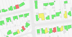
– Risk models range from geographical areas to individual addresses
While fire services analysts can perform their own geospatial modelling, an increasing number of customers are choosing the NECSWS consultancy service. It provides a good option when fire service internal resources are limited or committed to other projects and allows customers to benefit from external validation. Crucially, independent modelling provides a defensible evidence base for decisions that may be challenged by stakeholders, politicians, or communities; particularly when station relocations, crew changes, or resource deployment are under consideration.
Cover, command and workload changes
One of the areas seeing the most immediate benefit is operational cover modelling. Services can examine how changes in appliance availability, station configuration, or staffing arrangements affect coverage in real-time. Dynamic models help identify where resilience is strongest and where it is most vulnerable.
The need for more sophisticated modelling has been driven in part by the complexity of modern workloads. Scenario modelling for testing the impact of new duty systems, revised shift patterns, or appliance relocations has become an essential planning tool.
Other areas where services are increasingly relying on location intelligence include:
Incident command support
Digital mapping, mobile access to risk data, and integrated information layers provide incident commanders with more confidence and situational awareness on the ground.
Response standard evaluation
GIS allows services to assess blanket or risk-adjusted attendance standards using real travel and operational data, enabling more nuanced local performance analysis.
Community risk assessment
The fire sector has long been rooted in operational expertise and community connection. Holistic profiling helps reveal patterns relating to deprivation, vulnerability, property characteristics, or demographics that may correlate with fire risk.
Targeting and prioritisation
Prevention and protection activities such as Safe and Well visits, audits, and community campaigns can be geographically targeted to maximise impact.
On‑call recruitment
Demographic and real-life road speed analysis helps services understand the workforce potential around on‑call stations.
Post-change evaluation
After implementing policy or structural changes, services increasingly use modelling to test whether the expected improvements have materialised.
In summary, the fire services sector is moving towards location intelligence-led modelling not just as a technical tool, but as a central part of decision-making. The expectation of evidence, whether from HMICFRS, local leaders, or communities, has made independent, auditable modelling essential. As risk patterns continue to evolve, fire and rescue services are likely to lean even more heavily on data, modelling, and geospatial intelligence.
For NECSWS, demand from fire services ranges from fully outsourced modelling projects to quality assurance reviews of in-house analysis. The goal is always the same: give organisations confidence in the decisions they make today and the plans they prepare for tomorrow.
NECSWS offers a range of consultancy work packages to support Fire Services. For more information, go to: necsws.com/gs-services
__
Read the full article in UK Fire magazine here.